
On our journey across Arizona it became apparent that we were not going to encounter the kind of dry, warm weather we had hoped to find, so outside of Flagstaff the gals decided that south was the only direction we could drive and Canyon de Chelly would have to wait for another time when the weather was warmer. South it was and Camp Verde east of Hwy.17 made us believe we might be getting warmer soon. It was on to Apache Junction and 74 degree weather. Nights were still chilly but short sleeves and sun shine went a long way to recharge the old batteries, the gals said. I loved just lazin’ around, moving from sun to shade and back again. We all sort of hung out in a little RV park, did laundry, slept, brushed me, did minor repairs and cleaning – all that boring stuff, but it felt good. Our walks were laid back except for a few bunnies that needed chasing and a donkey that wasn’t sure he wanted to play tag. The world finally felt warm and fuzzy again.
We moved over to Mesa for a week partly to get a leak in the Pod’s plumbing repaired and to strategize a series of excursions for picture-taking and fact gathering for the educational book project. One thing we all discovered and agreed upon is that we are not big city folk at all. Just driving around the area, being caught up in the traffic with too many people and vehicles, parked in RV Resorts with too many rules and regulations, is not a life we want to live. Or as a friend of Kae’s used to say, “It vitiated our vatas’! The old state capital building was interesting and while Cokie was trying to get a photo with none of those bureaucratic types in it, there was a major evacuation of the Senate building with hundreds of employees pouring out into the plaza plus police and fire personnel too. Seems they must have a really good alarm system or a great case of paranoia because some poor embarrassed employee simply burned their popcorn in a microwave in one of the employee lounges! The intrepid photographer got the picture anyway. There was a very well done veterans’ memorial park in front of the capital honoring Arizona fighting men in all of the US conflicts. Sad there have been so many.


In our research we also discovered the biggest water project in Arizona. Known as the Central Arizona Project, CAP. It runs right through this area and is the largest single source of renewable water in the state. These canals are the lifeline for the cities and agribusinesses in the center of the state and were constructed to offset the 2.5 million acre foot groundwater overdraft that had been occurring for years. CAP was completed in October 1993, cost over $4 billion to construct and is 336 miles long running from Lake Havasu in western Arizona to 17 miles south of Tucson.

 We decided to travel on toward Tucson by way of one of the scenic byways-Hwy.88, The Apache Trail, through the Superstition Mountains, site of the infamous Lost Dutchman Mine.

On the way we stopped at Tortilla Flat, site of an old Pony Express way station in the 1800’s but now a fun restaurant, museum and general store. Another one of those spots where people from around the world have left their mark by way of currency stuck all over the walls and ceiling. Seems Tortilla Flat was flooded in 1947 and burned down in 1987 only to be rebuilt each time. Rumor has it that the currency on the walls was worth more than the building when it burned in ’87!


Scenic byway 88 through the Superstition Mountains is very winding, steep and of course, scenic. There are three lakes in sequence – Canyon, Apache and Theodore Roosevelt; all very important, as you can imagine, to the viability of the surrounding area. These lakes lie like deep, blue and silver gems-cold and unfathomable, no trees or greenery on their shores, just there, reflecting sky and sunlight. They are surrounded by the great Sonoran Desert landscape of Saguaro, Cholla, Yucca cactus, sharp shaped mesas with cliffs and canyons; desolation broken only by these life giving lakes and seasonal rivers. A little riparian oasis of willow, ash and cottonwood may surprise you around a curve in the road and then the next curve will be sheer walls of billion year old stone, silent sentinels. This is definitely stark and hauntingly beautiful country.


We left our quiet little site near Tortilla Flat and spent the next few days in the Roosevelt Lake in the Tonto National Forest area. We visited the Theodore Roosevelt Dam, built between 1902 and 1911, as the premier feature of the Bureau of Reclamation’s Salt River Project. At the time of its completion the dam was 280 feet high, 723 feet long and 184 feet thick at its base. It was the highest masonry arch dam in the world and was among the last of the stone masonry dams to be built. The large stone blocks were actually carved on-site from the bedrock of the canyon and fitted into place. March 18, 1922, former President Theodore Roosevelt dedicated the dam named in his honor. Modifications to bring the dam up to current earthquake standards and to increase the capacity of the lake were completed in April, 1996.

The original dam top highway was designed to allow two model A’s to pass abreast but could not accommodate today’s wider RVs and trucks, so the 1080’ long Roosevelt Lake Bridge was constructed. It has been designated as the longest single span arched bridge in North America and also one of the top 12 bridges in the nation for overall design, size, eye-appeal and design challenge. Coincidently, it was deliberately painted blue to blend with the background of the sky and the lake and is known locally as “Big Blue”.


We spent several nights parked at Cholla Recreation area campground in the Tonto National Forest right on the edge of Theodore Roosevelt Lake. It was pretty much empty of any other RVers and so I could have run to my heart’s content except for the d--- cactus thorns and stickers all over the place. Oh well, I got in a couple of good swims and lots of frantic digging! My ladies thought it was way cool that this is the largest all-solar powered campground in the US.


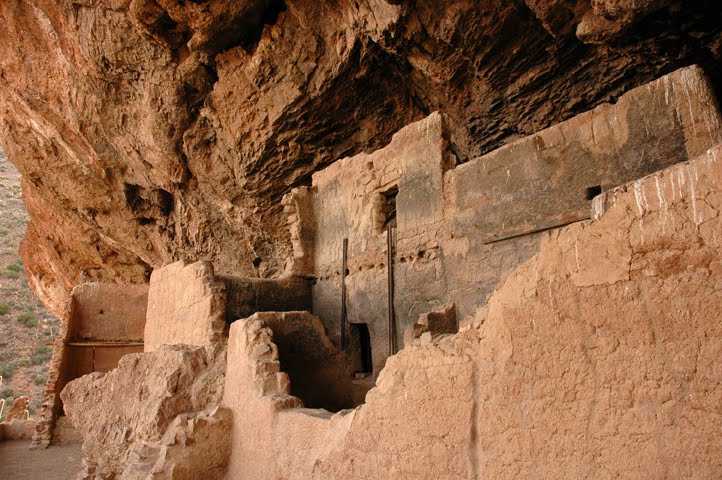
We spent part of one day at the Tonto National Monument which is the location of two large cliff dwellings of The Salado: People of the Salt River, who for 300 years made their living from what nature provided in this mountainous desert environment. Shallow caves have protected these ruins for more than 700 years, along with remnants of their society in the form of pottery, fabric pieces and handprints in the stucco on the pueblo walls. The gals visited the Lower Cliff Dwelling as the Upper Cliff Dwelling is by reserved tour only and I can’t go on these trails anyway, you know. (Pftttttttt!) We learned a great deal about a little known ancient culture. The Ladies have decided to also visit a reconstructed Salado site named Besh Ba Gowan near the little town of Globe for more information.


Next we traveled north across “Big Blue” up Hwy. 87 to Payson ( sweet, little city) and on to the Tonto Natural Bridge State Park, touted as the world’s largest natural travertine bridge. (Notice how these folks seem to go in for the biggest, largest, longest, highest sort of hyperbole? This is Arizona and not Texas, right?). This park is really spectacular and full of geologic information on its creation. So the hike was great, the rainbows and rock formations unbelievable and this tiny valley a real gem. We loved hiking and seeing it!


My ladies next spent several hours in the Arizona Archeological Museum in Payson having a private tour of the exhibits by one of the local retired archeologists. His knowledge of and enthusiasm for many of the local digs and sites was immense and he was quite entertaining. Many of the exhibits contained artifacts that he had found so his stories made the museum come to life. We spent a few more days in the Roosevelt Lake area then headed south toward Globe, Miami and Superior. These are old copper mining towns hanging on waiting for the price or need for copper to rise again. This is a recurring story throughout the west whether it is gold, silver, copper or whatever; but the number of ghost towns tells a different story. In Globe we visited the Besh-Ba-Gowah Archeological Park. This is a reconstructed 700 year old pueblo of the Salado people and is an experiential, self-guided tour through a very large pueblo. The name comes from Apache and translates as “place of metal.”


We stopped by the Ray Pit Mine outside of Miami and tried to photograph the enormity of this active open pit copper mine, one of the largest in Arizona. The rainbow hues of the various deposits exposed by the huge shovels gnawing away at the earth give this ‘scar’ an other worldly character and seem to soften the damage of man’s activities. It is hard to imagine the sheer scale of this pit but we hope the pictures will help.


Next was Boyce Thompson Arboretum State Park, a delightful botanical garden along Queen Creek, founded by copper baron Col. Wm. Boyce Thompson to foster an appreciation of arid land plants. It is filled with specimen plants from desert environments from throughout the world. This was way, way fun because well behaved gentlemen like my self are welcome on the trails and I loved all the plant and animals smells. I could have stayed for a few days.


On down Hwy 77 we spotted this little piece of ‘Americana’ in Mammoth. Just remember, folks this is AZ. not the so-called “Bible Belt" - God's Filling Station.


We ended up in Catalina State Park north of Tucson for a day and drove over to the Biosphere 2. Even though I spent a lot of time dozing in the Pod I overheard the Ladies conversing about what fabulous scientific and engineering marvels these structures are! This was the privately funded 1990’s experiment for creating and living in a completely enclosed, self-sustaining environment. You may recall that 8 people spent 2 years living in the Biosphere. There was a problem with increased carbon dioxide in the air. The analysis of the problem pointed to the fertilizers they were using to enhance the soil in the garden trying to enhance productivity as food was minimal. Additional oxygen had to be pumped into the biosphere, thus ending the completely self-sustaining aspects of the experiment. The five biomes – rainforest, desert, savanna, marsh and ocean are still functioning as well as were intended without any human residents to interfere or ‘muck’ things up. Sounds a bit familiar, huh? Here’s some data to comprehend: * The Biosphere 2 covers 3.15 acres. * It is 539 feet long and 91 feet high. * It is sealed off from contact with Earth by a 500 ton welded stainless steel liner. * The 25 foot ocean contains a million gallons of salt water. * The apparatus hosts some 3,000 species of living organisms. Columbia University was the project manager for a few years and made some dramatic changes to the project, among them dozens of student housing structures. Colombia did not renew the contract once it had expired and no new project managers have been forthcoming. As a consequence the entire facility, other than the biosphere and its support buildings, has been shut down and the private funding plus tour income is barely sustaining its needs. There is a sense that this unique, one of a kind facility will one day simply be shut off, shut down, left to the desert and to its own devices. Of course I much prefer the sights and smells of the great world we live on but I can’t help wonder if this experiment gone awry might be an indicator of the fate of our own Biosphere 1, Earth.


We next traveled west of Tucson to Saguaro National Park for a few days in a nice desert campground near the Tucson Mountains. This area has the highest concentration of saguaro cactus in the state, hence the name. (Well, duh!) The birds were prolific right in the campground and made hanging out very interesting for an old ‘bird dog’.


The gals went off to the Arizona-Sonoran Desert Museum and were way impressed by the living desert exhibits, animal habitats, gardens and docent demonstrations. The New York Times described it as …”probably the most distinctive zoo in the United States…It is a combination of museum, zoo, botanic garden and nature trail. One of a kind…not to be missed.” I couldn’t go inside but again I always get to smell where the gals have been and I am a really good listener.
Here is a short list of some of the things they saw:
Reptiles and Invertebrates safely tucked behind glass
Earth Sciences in a limestone cave, with a spectacular collection of mineral and gem specimens found in the region
Mountain Woodland with live mountain lions and black bears
Desert Grasslands with a prairie dog town Cat canyon with bobcats, ocelots and jaguarundis Desert Loop Trail with views of the surrounding valleys, hills and exhibits still under construction Riparian Corridor with its little herd of javelinas Bird Exhibits, including the Raptor Free Flight Program
The Ladies did not take time to see all of the exhibits and demonstrations as they claimed they were worried about me out in the Pod, but I think they got tired and will just plan to come back again someday to see the rest of the museum.


Next was south-eastward to the far corner of Arizona near Tombstone and Bisbee. We found a comfortable RV park well situated in the middle of a whole lot of things we wanted to see in the area. We stayed several days and explored. This park was one of those great places where I could be off-leash and boy did I run and dig and sniff ‘til my old doggie heart’s content! Now Tombstone is famous, as we all know, for the ‘Fight at the OK Corral’, Wyatt Earp, Doc Holiday and the rest of the gang plus the Boothill Graveyard.


Well okay, the Wild West is fine, but they have taken this whole thing a bit far in my opinion. It may be a proud re-creation of an 1880’s town but, lordy, there must be a gunfight every hour or more somewhere in town. Just a bit noisy for sensitive doggy ears, if you know what I mean!


I didn’t want to walk around too much so the Ladies took off and did the photography bit. Kae had read about one of those hyperbole things again – the world’s largest rose bush – and dang, there it was with its own house/museum too. The house has its own long and colorful history but the rose was the reason for the visit, so here is its story. It was planted in the spring of 1885 as a small shoot from a Lady Banksia Rose bush sent from Scotland to a young bride, Mrs. Henry Gee. Mrs. Gee gave the shoot to her friend Mrs. Amelia Adamson as a token of their friendship and together they planted it in the patio area of the yard. Subsequent owners nurtured the bush, built it an elaborate pipe and pole trellis and added to the trellis as the bush grew and grew. Today the Lady Banksia, with millions of white blossoms every April, spreads over 8000 square feet and is still growing! Of course, this was not the prime season, but you get the idea. ‘Worlds largest’ does apply this time.


Between Sierra Vista and Bisbee is a unique little National treasure, Coronado National Memorial. This is cultural area in a natural setting composed of 4,750 acres of oak woodlands and sweeping vistas. It commemorates the first major European exploration of the American southwest and lies within sight of the valley through which the expedition of Francisco Vasquez de Coronado and his company of soldiers and missionaries first entered the present-day US in 1540. We all had a great day playing, driving and hiking up Montezuma Canyon to the Montezuma Pass Overlook.


Next destination was Bisbee. Now the gals were going there to take the Copper Queen Mine Tour, a mine train tour of one of the most productive underground copper mines of the 20th century but they were surprised by the quaintness, beauty and energy of the town itself so we came back three different times. The mine shows just a hint of the richness of not only copper but an amazing array of minerals and semi-precious stones that are found in these mountains.


The local museum is installing an extensive exhibit of the mines, minerals and history of Bisbee. Created in association with the Smithsonian Museum, this interactive exhibit will be the first display completed in the Smithsonian’s Rural Affiliate Museum Program. It should be completed in October, 2006 and I’ll bet the Ladies will be back!

Founded in 1880, Bisbee was once the largest city between St. Louis and San Francisco. Today it is preserved through the National Historic Register and reflects its past culture and Victorian charm. Walking the streets is a step back in time and history meets you everywhere - in the mine tour, at the open pit Lavender Mine (home of Bisbee Blue, a very rare, high quality turquoise), in the museums, the shops, the restaurants, even the Post Office. I highly recommend a visit there.


After Bisbee we turned north to still try to work our way up to The Petrified Forest and Canyon de Chelly in the north eastern part of the state. Gals decided to stick to Hwy.191 all the way with side trips to such special places as Cochise Stronghold in the Dragoon Mountains and Chiricahua National Monument. Chiricahua NM reminded all of us of the great pinnacles and towers of Bryce Canyon in Utah. The colors are different but the artwork of erosion and wind is just as spectacular. The Chiricahua Apaches used these rugged rocks as hideaways and refuges from the U.S. Army and its dedication to rounding them all up for confinement on the reservations. These people were the last to stand against the white man’s taking of their land in the great westward expansion of America. These sites are still sacred to the Apache Indians and are interesting, sweet places to stay. The great chiefs, Cochise and Geronimo, are honored in this area, so I loved the sense of the spirits and the guardians, plus the smells of the wilderness, still prevailing there.


We found a really wonderful spot called the Gila Box Riparian Conservation District run by the BLM outside of Safford off Hwy.191. Several things made it wonderful – no other RVs, the whole Gila River to play in, 40,000 acres of wilderness, lots of ground critters to smell, dig for and chase plus sunshine, sunshine, sunshine! We stayed several days and were still going to work our way northward when we saw the national weather forecasts about freezing temperatures and snow as far south as northern AZ. Lots of rain was in the forecast and we didn’t want to get caught in any flash floods so boy, did we do a quick 180!


Okay, back we went to Saguaro National Park east of Tucson, warmer weather and the re-grouping of our general direction and points of interest. We visited some more little treasures in this area like the Amerind Foundation, a museum of Native American archeology, art, history and culture. This is a beautiful facility dedicated to the preservation and interpretation of Native American cultures from Alaska to South America, from the last Ice Age to the present. The Ladies spent hours there and would have stayed longer except for little things like dinner, darkness and closure. Unfortunately, they did not allow photography so you will have to go to see these treasures for yourselves someday.
Kitt Peak National Observatory, west of Tucson, on the way to Yuma was the next adventure. This is the world’s largest (here we go again!) collection of research telescopes and is located high (6,875’ elevation) above the Sonoran Desert on the Tohono-O’odham Indian Reservation. Home to 23 optical telescopes and two radio telescopes, Kitt Peak represents dozens of astrological research projects and institutions. I took up my guard duties and the Ladies took off for three tours to 3 different telescopes. They said the sheer massiveness of the structures to house and maneuver the larger telescopes was one of the wonders of Kitt Peak. Even more wonderful is the information being gathered as the world’s astronomers explore deeper and deeper into the universe learning more and more of the beautiful and dynamic life and death creation processes.


This facility is located on the second most sacred mountain to the Tohono-O’odham people, so they were smart and only leased the land to the US Government starting in 1958. Baboquivari, ‘center of the world’ for their creation God is located southeast of Kitt peak and is their most sacred mountain. It too is a very impressive sight as it rises nearly 8,000’ above the vast desert basin.

Pressing ever westward and staying in all of the sunshine and warmth we can find, we went south to Organ Pipe Cactus National Monument on the American-Mexico border. Another great park with lots to watch, walk and smell. By now you are probably wondering why we keep taking off for more desert regions. Well, firstly, that’s about all there is out here in the southwest, don’t ya know? Secondly, I just want warmth on these ‘getting older’ bones and thirdly, every one of these desert regions is a unique bio-system, often with plants or animals found only in that particular area. Case in point a little blue fish named Quitobaquito (KEE-toh-ba-KEE-toh) pupfish. This fish is found no where else on Earth except here in Organ Pipe National Monument in the heart of the Sonoran Desert. Until recently it was found only in one threatened spring area. Local school children in cooperation with the Park Rangers have recently built another pond habitat behind the Park Visitors Center and transported 234 pupfish over to their new home. The fish are thriving, the children are learning a great deal about ecology management and the Quitobaquito has been given a new chance. More fellow critters could use that kind of caring cooperation. The National Park is named after the Organ Pipe Cactus, a large, multi-branched cactus found rarely in the USA although it is common in Mexico.


A few days spent at Organ Pipe NP and on to Yuma and environs, then ever westward ho. We spent a quick visit outside of Yuma in a bad park next to a railroad. At least the Ladies got showers and smelled a whole lot better; did laundry and got the Pod cleaned. I let them know that I needed a bath too and would appreciate a quieter place where I didn’t feel the whole Pod shake several times a night! Kae found a quiet little lake on the California side of the Colorado River out in a tract of BLM land. So off we went continuing the saga of two old Dogs and their handsome canine friend!
No comments:
Post a Comment